Redistricting 101: Your District, Your Politicians, But Does Your Vote Matter?
A beginner’s guide to how Lansing’s politicians choose their new voting constituencies.

An Introduction to Redistricting:
- Voters elect someone to represent them in Congress and the state Legislature.
- That individual represents a geographic area called a “district.”
- To ensure no district has more power than another, each one must have roughly the same population.
- Every 10 years, state lawmakers use the latest data from the U.S. Census to draw district boundaries.
- If the population shifts, the boundaries change to reflect that dynamic.
- The process creates three distinct maps, for three different bodies of government: U.S. congressional Districts, state Senate districts and state House districts.
- No map is the same. All of are decided by your state politicians.
How Politicians in Lansing Redistricted Michigan

The last time the district lines changed, state Sen. Steve Bieda (D-Warren) was the minority vice-chair for the Michigan State Senate Committee for Redistricting. That was 2011, when Michigan Republicans took control of the State Senate, State House, and with the election of Gov. Rick Snyder, the executive branch as well.
“In the minority, of course, you don’t have the votes that a person has in the majority,” said Bieda, whose own district spans the southern portion of Macomb County. “At the end of the day, [the Republicans] came forward, said, ‘this is what we have, and this is what we’re going to do.’”
With the Democrats in the minority, Republicans controlled the redistricting process and were able to draw all three maps in ways that would secure more districts for the Michigan GOP in future elections, even if Democrats get more votes overall, Bieda said.
That’s process to create political security just in how the maps are drawn is called gerrymandering.
When it comes to redistricting, Bieda says there’s another issue at stake beyond political gerrymandering.
“We tend to look at redistricting as one party over the other, but a lot of the times you’re seeing members of the majority party, and for that matter, members of the minority party putting forward ideas that clearly benefitted them personally.”
State Sen. Steve Bieda, Michigan’s 9th District
Some committee members drew lines to benefit themselves personally, Bieda says, mainly in areas with strong political leanings towards one party or the other.
“They worked out what those districts would like,” Bieda says. “[The Republicans] couldn’t care less because they’d knew they’d have seats that were Democratic, but they would ask them to vote for the plan so it would look bi-partisan.”

Bieda says committee members would draw district lines to cut out incoming political challengers or to include areas where the members grew up. By state law, Michigan politicians are supposed to draw districts that are compact and keep cities and counties together as much as possible.
Densely populated areas like Detroit have to be divided to some extent, but how the city is divided is a matter of interpretation for those on the state redistricting committees. Republicans on those committees declined to speak with WDET due to pending lawsuits over redistricting. But a GOP consultant who’s familiar with the process did respond. Jamie Roe said when it comes to drawing Detroit’s congressional districts, the committees must follow federal law.
“The federal Voting Rights Act, when it was passed in 1964, required if you can build majority-minority districts—and in this case, two majority African-American districts, which Detroit has had since the advent of the voting rights act, then you must build two African-American majority districts.”
Jaime Roe, Republican Political Strategist
The same federal laws apply to Detroit’s state House and Senate districts. As a result, a single neighborhood can be in more than one district.
In Detroit, District Maps Get Interesting
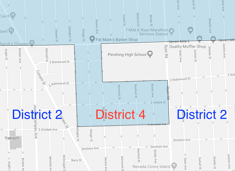
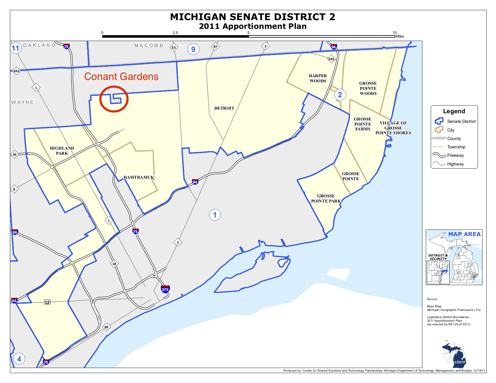
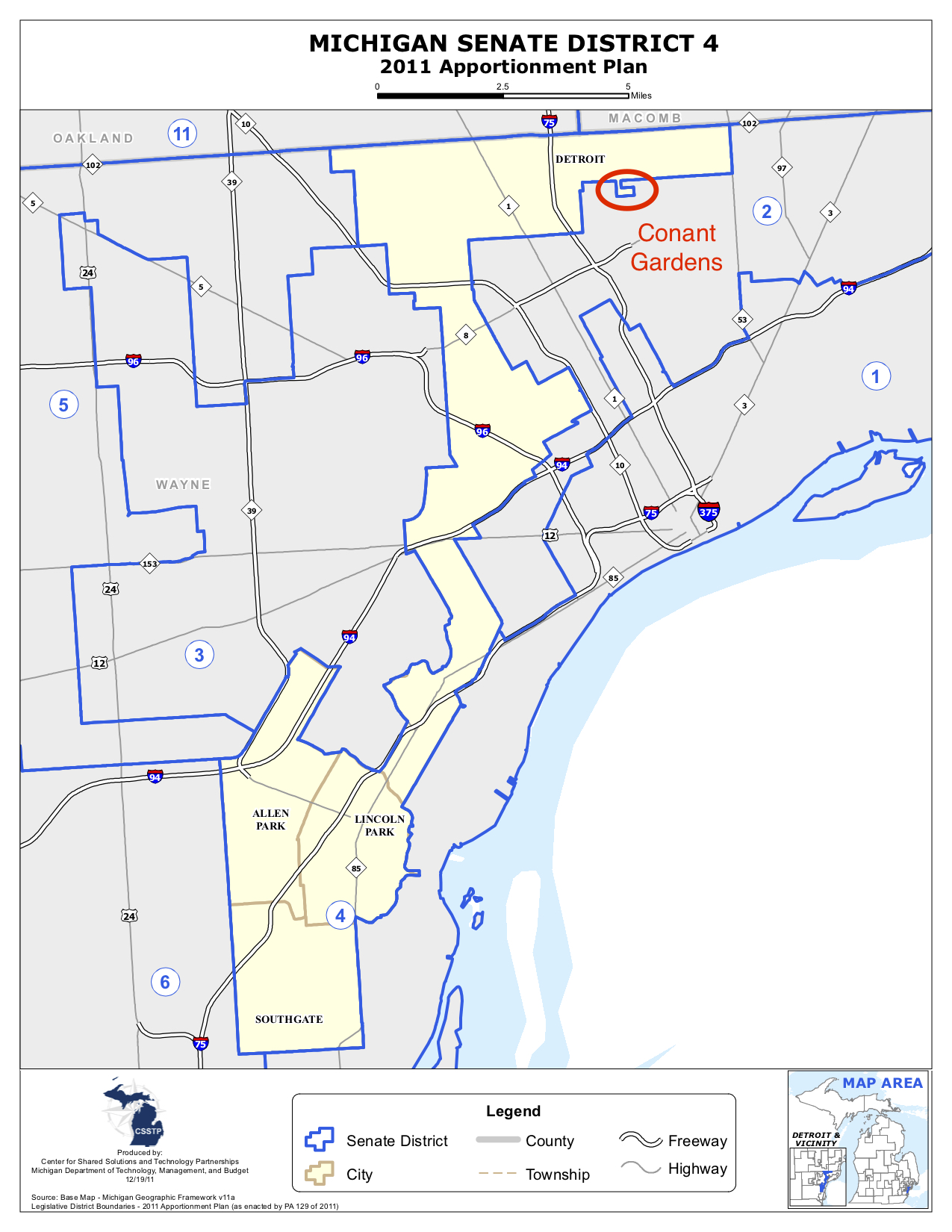
Conant Gardens, a historic neighborhood in northeast south of Seven Mile Road on Ryan Road, shows how small some of these state district areas can be.

Michigan state Senate District 2 covers most of Detroit’s east side, Harper Woods, and the Grosse Pointes, but also stretches south towards Highland Park and southwest Detroit. Michigan state Senate District 4 similarly covers the east side of Detroit, but follows a path downriver to include Allen Park, Lincoln Park and Southgate.
Former state Sen. Virgil Smith grew up in Conant Gardens, and, like Bieda, was on the state Senate Redistricting Committee in 2011. Smith told WDET the reason why Michigan state Senate District 4 has this small deviation was so he could include his own house within its political boundaries.


Here’s other WDET work on the gerrymandering issue:
Policy Meets the People: Introducing the Issue of Gerrymandering
Talk Show Programming
WATCH HERE: A live one-hour show with an in-studio audience and guests at 8 p.m., Tuesday, June 26. Tune in at 101.9 FM or online at WDET.org. Or join on WDET’s Facebook page where we’ll live stream the show. The show rebroadcasts at 2 p.m. Tuesday, July 3. Listen HERE for WDET 101.9 FM live online.
On DETROIT TODAY: Was Racism Involved in the Drawing of Michigan’s Congressional Districts?
Digital Specials
A Podcast Playlist – Become a Gerrymandering Expert Just By Listening
NPR’s Hidden Brain: Gerrymandering and You
News Coverage
MichMash: Here’s How You Can Influence The Drawing of District Lines in Michigan
Gerrymandering: Why It’s a Technology Issue [TRANSCRIPT]
Redistricting 101: Your District, Your Politicians, But Does Your Vote Matter?
Ohio Offers Its Own Solution to Gerrymandering [MAPS + GRAPHS]
Who Should Draw Michigan’s Political Maps? Voters May Decide [PHOTOS + MAP]
Voters Not Politicians: The Pros [TRANSCRIPT]
Voters Not Politicians: The Cons [TRANSCRIPT]
It’s a Ship….No, it’s a House…Wait, it’s a Congressional District?
Does Michigan Have a District that Looks Like Homer Simpson? You Be the Judge.
Facebook Fun
