The Year in Weather; Bitter Cold, Ice Storm, and Tornadoes [MAPS + GRAPHS]
National Weather Service reviews most significant events of 2018 in Metro Detroit.

Oh, the weather outside was occasionally frightful in Metro Detroit this year.
We had it better than other parts of the country, hit hard by hurricanes, blizzards, and wildfires. A handful of events were noteworthy, however. 2018 began in the midst of a 12-day cold streak. From Dec. 26, 2017 through Jan. 6, the temperature never rose above 20 degrees Fahrenheit. It was the longest such cold spell in almost 40 years.
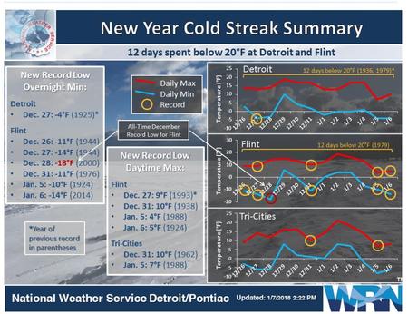
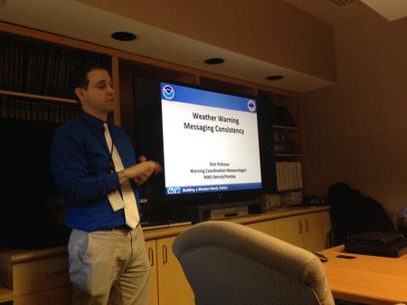
“We just had an arctic air mass in place,” says National Weather Service meteorologist Rich Pollman. “And we just kept getting a reinforcement shot every two or three days. So every time the air mass tried to modify, there was just another reinvigorating shot of arctic air that came down from the northwest.”
The cold was a memory by the time February came around. The high on Feb. 20 set a record at 65 degrees. Winter returned in mid-April, when an ice storm coated the southern Lower Peninsula, bringing down tree limbs and power lines. Pollman says ice storms that late in the season are rare.
“We had ice accumulations between 1/4-inch and 1/2-inch over much of Metro Detroit,” Pollman says.
As spring turned to summer, things heated up. The hottest days of the year occurred when the high temperature reached 96 degrees on June 16 and 17, and again on July 5–capping a week-long stretch of highs in the 90s.

The first tornado of the season–and the first in the tri-county area since 2015–touched down just as August began. The twister was weak and short-lived, but did damage some commercial property on Eureka Rd. in Taylor. The funnel formed at 12:44 a.m. on Aug. 1 and lasted two minutes.
Three more tornadoes touched down between 8 and 9 p.m. on Sep. 25. These twisters damaged property in Berlin Township, Gibraltar, and Grosse Ile, with top winds estimated at 100 mph. Pollman says they all developed from the same severe thunderstorm.
Overall, however, Pollman says, “it was a light severe weather year” in southeast Michigan.
This interactive map details September’s tornado damage
2018 will end up being one of the wettest years on record for Metro Detroit.
“We’re going to have 42 or 43 inches of rain when we get done with this year,” Pollman says. “That will put us between the fifth- and seventh-wettest years on record.” The government started keeping weather statistics in Detroit in 1874.
Click on the audio player to hear the conversation with WDET’s Pat Batcheller.