
A Hot Weekend, But No Repeat of 2016 Expected
Ridge of high pressure brings 90 degree weather to Metro Detroit
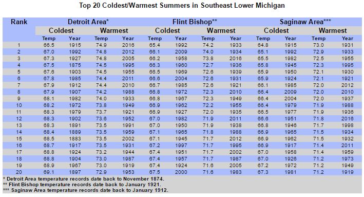
The summer of 2016 was the warmest ever recorded in Metro Detroit.
So what can we expect this summer? Something closer to normal.
Rich Pollman is the warning coordination meteorologist at the NWS office in White Lake Township.
“There’s really no clear climate signals that are leaning one way or the other for southeast Michigan,” Pollman says. “So the best bet is to go with a forecast that’s going to be for typical temperatures.”
But Pollman says hot weather is coming from the southwestern U.S., with high temperatures near 90 degrees starting Sunday, June 11.
“We’ve got a big ridge of high pressure both at the surface and aloft that also helps to warm the atmosphere,” Pollman says. “And that starts developing Saturday, and then especially for Sunday, Monday, and Tuesday. Those three days especially look like our hot days.”
Pollman is also forecasting normal to slightly above average rainfall this summer, though specific amounts could vary depending on how strong this season’s thunderstorms will be.
“And so while one thunderstorm may affect a localized area with five inches of rain, somewhere five to 20 miles away may only see a tenth of an inch,” Pollman says.
Read the summer outlook below:
Detroit Summer 2017 Outlook by WDET 101.9 FM on Scribd